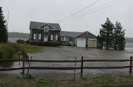
Super-storm Sandy and other recent water-based natural disasters have catalyzed action by the Fed’s. Last month the Federal Emergency Management Agency (FEMA) released new maps of flood zones in the USA. The new maps reflect better data about the effects of waves, tidal surges, storms, and other flooding events. Many homes close to coastal areas and rivers were affected: their projected risk to flooding was increased.

Here is our new report of concerning the new Flood Zone maps:
-New FEMA Flood Zones affect Cape Cod properties
The new flood zone maps will require many homes to secure flood insurance, and those homes moved to more severe flood zone demarcations will experience insurance cost increases.
- Will your property be affected?
- What relief, if any, will property-owners have if they are re-mapped up into a higher risk zone than they were in before?
- For properties that are re-mapped up, will there be major consequences?
- What if my structure is re-mapped up and I do nothing?
- How can I know for certain that I will be grandfathered?
- Does grandfathering end when I sell or convey my property?
- Is my grandfathered lower risk rate jeopardized if I change insurance carriers?
- My insurance agent has never heard of grandfathering of flood insurance risk rates. What should I do?
-New FEMA Flood Zones affect Cape Cod properties
Get answers to these and other questions with our report on the effects of the new FEMA Flood Zone Maps. If you have questions which the report doesn’t address, please don’t hesitate to call us any time: 508-394-3090.
-New FEMA Flood Zones affect Cape Cod properties


